In the realm of construction and excavation, accurate utility locating is paramount to avoid costly mishaps and ensure the safety of both workers and the surrounding community. Traditional methods of utility locating often involve guesswork and trial-and-error, leading to inefficiencies and potential hazards. However, the advent of advanced technologies has revolutionized this process. At ACS Underground Solutions, we are at the forefront of transforming utility locating through cutting-edge techniques like concrete imaging. Below, we will explore the significance of concrete imaging, its benefits, and how it is reshaping the landscape of utility locating.
The Evolution of Utility Locating:
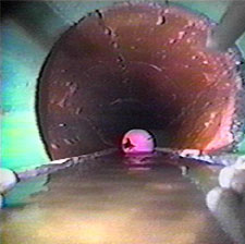
Before delving into concrete imaging, let’s reflect on the traditional methods of utility locating and the challenges they pose. Conventional approaches typically involve using electromagnetic equipment or ground-penetrating radar (GPR) to detect utilities beneath the ground. While these methods are valuable, they often fall short when dealing with complex urban environments or areas with extensive concrete structures.
Challenges with Traditional Methods:
- Limited Penetration Depth: Electromagnetic equipment and GPR may struggle to penetrate certain materials, resulting in incomplete data collection and a lack of visibility into deeper utility lines.
- Ambiguity in Concrete Environments: Concrete structures can cause interference and distort readings, leading to inaccuracies in utility location. This is especially problematic in urban settings where underground utilities and concrete infrastructure are prevalent.
- Time-Consuming and Costly: Traditional methods are often time-consuming and may require multiple passes to obtain accurate data. This not only extends project timelines but also adds to the overall cost of utility locating.
Concrete Imaging: A Technological Breakthrough
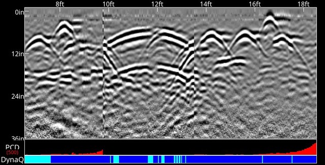
- Principle of Concrete Imaging: Concrete imaging, also known as concrete scanning or ground-penetrating radar (GPR) concrete imaging, relies on advanced radar technology to penetrate concrete structures and provide a clear visualization of embedded utilities. It is a non-destructive and non-invasive method that offers a comprehensive understanding of what lies beneath the surface.
- How Concrete Imaging Works: The process involves transmitting radar pulses into the concrete, and the signals bounce back differently based on the materials encountered. The data is then analyzed to create detailed images, revealing the location, depth, and composition of utilities within the concrete structure.
- Benefits of Concrete Imaging:a. Precision and Accuracy: Concrete imaging excels in providing precise and accurate information about the location of utilities. It offers a detailed view, helping to identify not only the presence but also the depth and type of utilities within concrete structures.
b. Versatility in Concrete Environments: Unlike traditional methods, concrete imaging is specifically designed to navigate the challenges posed by concrete structures. It can effectively scan through various densities of concrete, providing reliable results even in the most complex urban environments.
c. Non-Destructive and Non-Invasive: One of the key advantages of concrete imaging is its non-destructive nature. This means that utility locating can be performed without causing any damage to the concrete structure, reducing the risk of unforeseen complications during construction or excavation.
d. Time and Cost-Efficiency: By offering accurate and comprehensive data in a single pass, concrete imaging significantly reduces the time and costs associated with utility locating. Project timelines can be streamlined, and resources can be allocated more efficiently.
e. Enhanced Safety: The precision of concrete imaging contributes to improved safety on construction sites. With a clear understanding of the underground environment, workers can avoid accidental damage to utilities, minimizing the risk of injuries and project setbacks.
Concrete Imaging in Action:
- Construction Projects: In construction projects, where accuracy is paramount, concrete imaging plays a crucial role in pre-planning and ensuring that utilities are identified and accounted for before any excavation begins. This helps prevent delays, cost overruns, and potential accidents.
- Renovations and Retrofits: When renovating or retrofitting existing structures, concrete imaging becomes an invaluable tool. It aids in identifying hidden utilities within concrete walls and floors, allowing for modifications without compromising the integrity of the structure.
- Infrastructure Development: Urban environments with extensive concrete infrastructure pose unique challenges for utility locating. Concrete imaging proves instrumental in navigating these complexities, providing a comprehensive view of subsurface utilities for efficient planning and execution.
Concrete imaging stands as a transformative technology in the field of utility locating, addressing the limitations of traditional methods and opening up new possibilities for accuracy and efficiency. At ACS Underground Solutions, we embrace this cutting-edge approach to ensure that our clients receive the most accurate and reliable data when it comes to underground utility mapping. As we continue to witness advancements in technology, the art of utility locating is evolving, and concrete imaging is at the forefront of this transformative journey. Contact ACS Underground Solutions today to experience the benefits of concrete imaging and revolutionize the way you approach utility locating in your projects.